


Ground Penetrating Radar
Ground Penetrating Radar (GPR) is a non-invasive technology used to investigate what lies beneath the surface before excavation begins.

-
Residential Construction
Ground Penetrating Radar is commonly used before building extensions, pools, retaining walls, fencing and landscaping to identify buried utilities before excavation.
Civil Construction
GPR assists contractors with trenching, roadworks, utility installations and infrastructure upgrades by locating underground services before work begins.
Commercial Developments
Developers use GPR before piling, concrete cutting, drainage works and new service installations to minimise delays and reduce the risk of utility strikes.
Utility Investigations
Where utility plans are incomplete or inaccurate, GPR helps identify unknown underground services and structures that may not appear on existing records.
Hall Surveying provides a more comprehensive understanding of underground conditions. Every investigation is supported by professional site mark-outs and detailed reporting to help minimise the risk of utility strikes.
Electromagnetic Locate
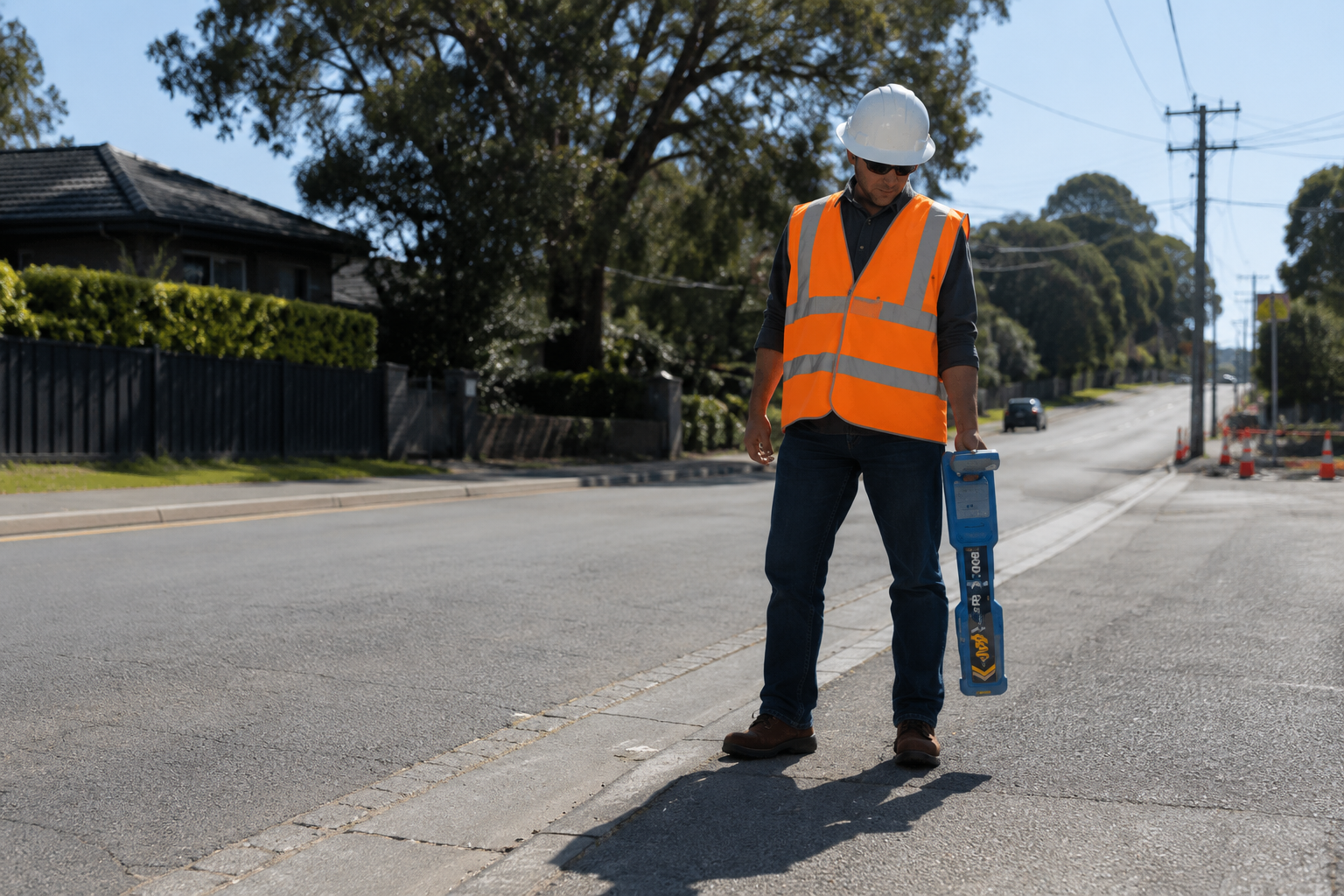
Electromagnetic (EM) locating is highly effective for tracing power cables, telecommunications, tracer wires and metallic pipelines over long distances.
When combined with Ground Penetrating Radar, electromagnetic locating provides greater confidence by identifying utilities that either method alone may not detect.
┃
Using transmitted electromagnetic signals, EM locating identifies and traces conductive underground utilities with a high level of accuracy.
Precision Reporting
Every utility investigation is supported by a clear, professionally presented report containing marked-up site photographs, utility plans, findings and recommendations.
Clear reporting transforms complex underground information into practical guidance you can confidently act on.
┃
Our reports provide clients with the information they need to plan excavation safely, communicate findings to contractors and maintain a permanent record of the investigation.
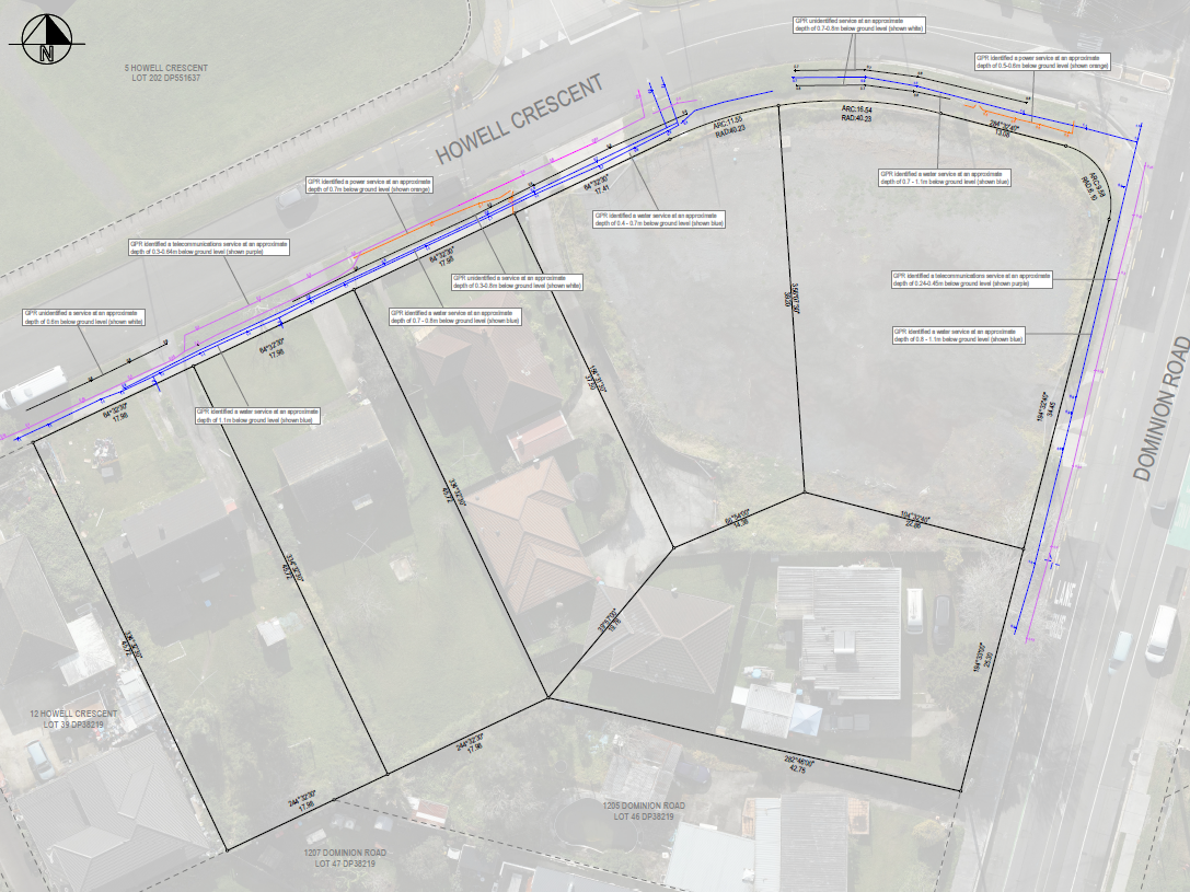
Professional Site Marking
Once underground utilities have been identified, they are clearly marked on site using industry-standard colours and symbols. This provides contractors with a practical reference before excavation begins.
┃
Clear, consistent service marking helps reduce excavation risk and improves site safety for everyone involved.
Every mark-out follows recognised utility colour standards and is supported by detailed reporting, ensuring underground services are clearly communicated before work begins.
Still Have Questions ?
Every site is different. Ground conditions, utility records and construction methods all influence the best locating approach. If you're unsure whether Ground Penetrating Radar is right for your project, contact Hall Surveying for advice before you excavate.
Frequently Asked Questions
-
Ground Penetrating Radar uses high-frequency radio waves to detect changes beneath the ground surface, helping identify buried utilities, voids and underground structures without excavation.
-
GPR can detect metallic and non-metallic utilities, including water pipes, stormwater, wastewater, electrical conduits, fibre ducts, concrete reinforcement, buried structures and unknown underground objects.
-
Yes. Unlike electromagnetic locating, GPR can often detect non-metallic services such as PVC and polyethylene pipes, depending on soil conditions, depth and pipe size.
-
Yes. Located services can be marked on-site using industry-standard paint markings to clearly indicate the estimated location of underground utilities prior to excavation.
-
Ground Penetrating Radar can be used in most weather conditions, although heavy rainfall and saturated ground may reduce penetration depth and image clarity in some soil types.
-
Yes. Hall Surveying provides Ground Penetrating Radar and underground utility locating services across the Auckland region.
-
GPR is highly effective, but accuracy depends on factors such as soil type, moisture, congestion of underground services and target depth. For the best results, Hall Surveying combines GPR with electromagnetic (EM) locating and available utility plans.
-
GPR and EM locating complement each other. EM locating is excellent for tracing conductive services, while GPR can detect both conductive and non-conductive utilities. Using both technologies provides a more complete understanding of underground infrastructure.
-
Detection depth varies depending on the antenna frequency and ground conditions. In favourable conditions, GPR can detect utilities several metres below the surface.
-
The duration depends on the size and complexity of the site. Smaller residential projects may take less than an hour, while larger commercial or infrastructure sites can require several hours or multiple days.
-
Yes. Utility plans remain an important part of any underground investigation. Hall Surveying reviews available utility records alongside GPR and EM locating to provide the most comprehensive assessment possible.
-
Yes. Every survey includes a professional report with annotated photographs, utility plans, site observations and our findings to assist with safe excavation.